
Keyword
Earth Science | Oceans | Ocean Chemistry | Nutrients
166 record(s)
Type of resources
Topics
Keywords
Contact for the resource
Provided by
Formats
Update frequencies
Status
draft
-
Detailed models, embedded within the MECO circulation model, of the primary production and nutrient cycling on the NWS. And a detailed model of the NWS food-web was developed using the Ecopath-Ecosim-Ecospace models and software (Bulman et al 2006), Also an agent-based model of the food-web was developed for the NWS, but was found to be slow and inefficient at large space scales and to give very similar outputs to the faster model of Bulman et al.(2006). From examination of all these models it was found that there was very little interaction between the human uses examined by the MSE and primary productivity, nutrient cycling or the food-web. Instead the major affects of the human uses were through the more direct consequences of harvesting, habitat modification and water quality. With respect to fisheries this is consistent with the findings of Sainsbury (1988). So while these other factors were maintained in the MSE model, primary production, nutrient cycling and trophic interactions were not explicitly included. At higher exploitation rates and contamination levels, or a different set of human uses, than is currently envisaged on the NWS it is likely that the impacts on primary production, nutrient cycling and trophic interactions would become important.
-
KSN Project 2.2.2 provides key information on the oceanographic and biological forcing associated with nutrient supply that determines the near-shore productivity of the Kimberley region, and links these with higher trophic levels. Key objectives of the research were - To make new estimates of pelagic primary productivity, identifying the key physical and community processes driving production in the region. - To better describe the phytoplankton and zooplankton communities in coastal waters of the Kimberley, to determine the trophic linkages within these communities and to identify the key factors controlling pelagic secondary productivity. - To integrate these parameters into an extensible biogeochemical modelling framework, allowing predictive linkages between physical and biological processes in the region. This metadata records specifically relates to modelling aspects of the project completed by CSIRO. The data originates from a number of model simulations conducted between 3/1/2010 to 21/12/2010. All field data are held at Pawsey and RV Southern Surveyor and RV Solander.
-
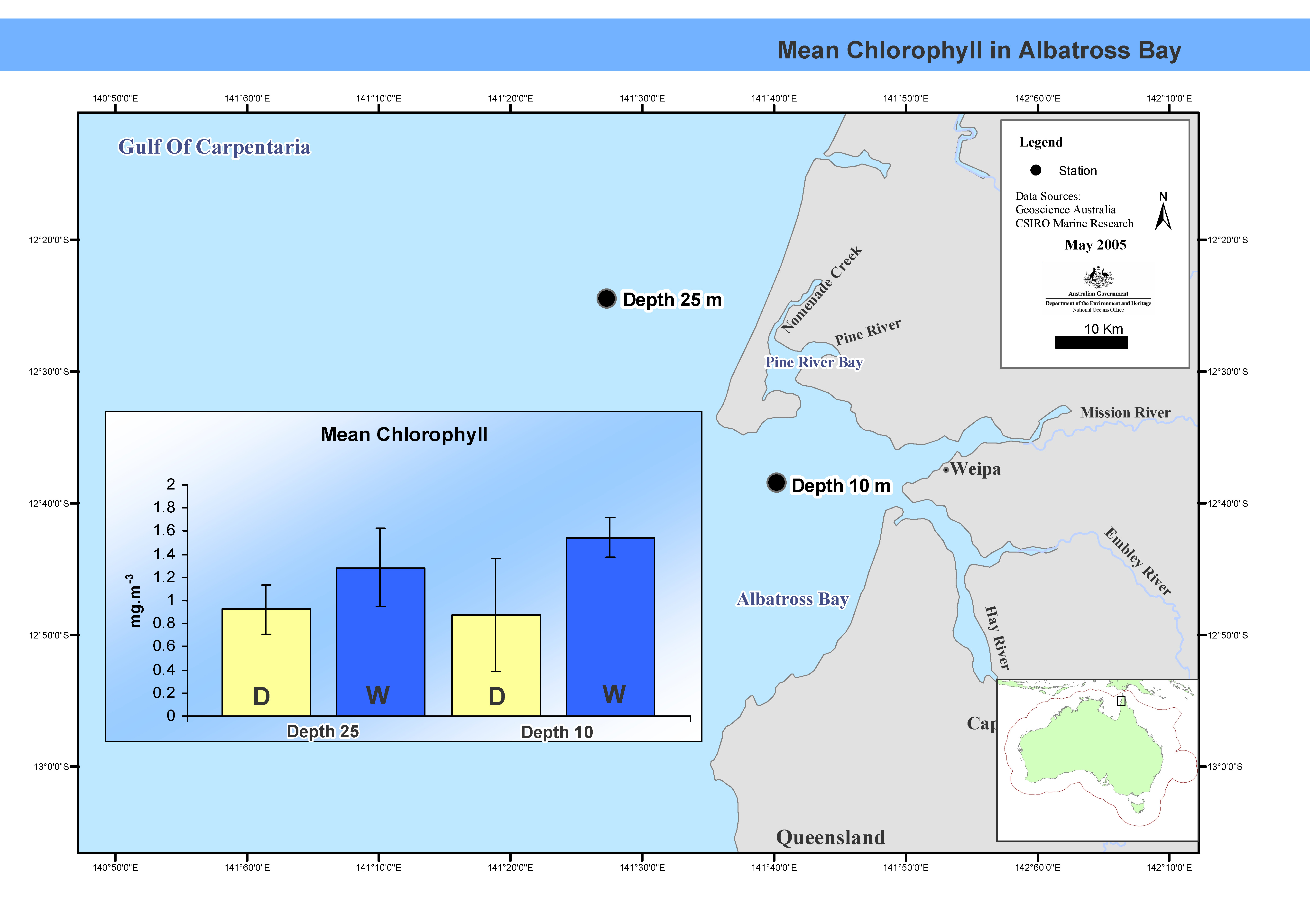
This map shows mean chlorophyll concentrations in Albatross Bay. Between February 1988 and February 1992 the FRV Jacqueline D completed nine cruises, seven in summer, two in winter, in Albatross Bay in the north-east Gulf of Carpentaria. Two stations, one 10m deep, the other at 25m, were sampled. Mean chlorophyl levels and primary productivity in the water column were measured. This map has been produced by CSIRO for the National Oceans Office, as part of an ongoing commitment to natural resource planning and management through the 'National Marine Bioregionalisation' project.
-
The current National Marine Bioregionalisation project, coordinated by the Nation Oceans Office, consists of both pelagic (water column) and benthic (seafloor) components. The intended outcome of the National Marine Bioregionalisation is a set of bioregions for the Australian Marine Jurisdiction which will underpin a spatial framework to support planning and management of Australia's oceans. This report outlines the work on the pelagic regionalisation. The Pelagic Integration project aims to map and describe pelagic bioregions of the Australian Marine Jurisdiction (AMJ) with a particular focus on regions offshore of the continental shelf. Where possible it will complement the existing shelf pelagic bioregions of the Interim Marine and Coastal Regionalisation of Australia (IMCRA v3.3). In the process of the current regionalisation, we expect to produce datasets and analyses that may assist with a future update of the IMCRA pelagic bioregions and their descriptions. Hence, results of this project should not be extrapolated onto the continental shelf. CSIRO Marine Research has responsibility for the Pelagic Integration as part of its contribution to a Consortium (along with the National Oceans Office and Geosciences Australia (GA)) effort in the NMB integration projects.
-
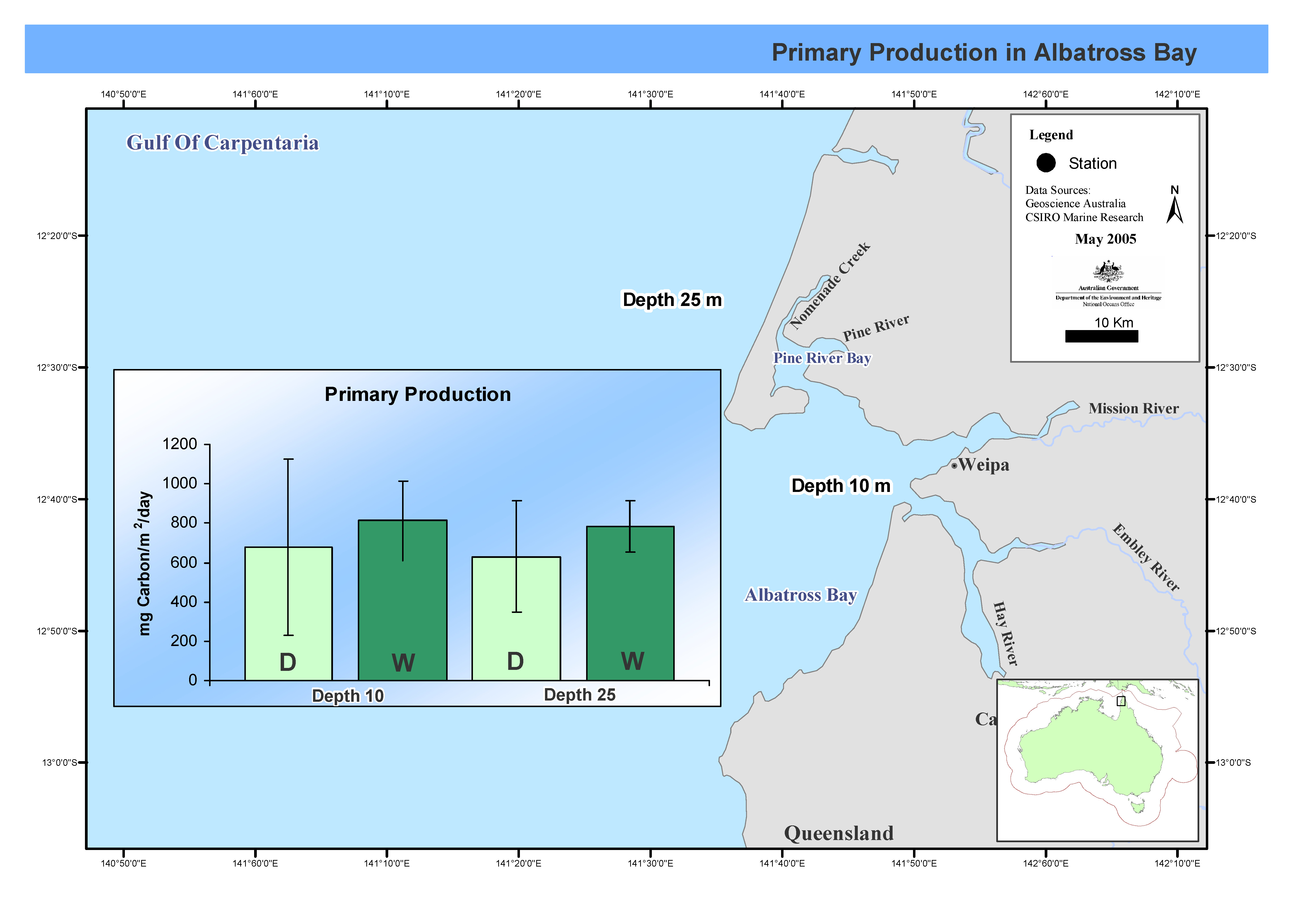
his map shows C14 primary productivity incubations at two stations over seven cruises in Albatross Bay during both the wet and dry seasons. Between February 1988 and February 1992 the FRV Jacqueline D completed nine cruises, seven in summer, two in winter, in Albatross Bay in the north-east Gulf of Carpentaria. Two stations, one 10m deep, the other at 25m, were sampled. Mean chlorophyll levels and primary productivity in the water column were measured. This map has been produced by CSIRO for the National Oceans Office, as part of an ongoing commitment to natural resource planning and management through the 'National Marine Bioregionalisation' project.
-
This record describes Hydrology (HYD) data collected from the Marine National Facility RV Investigator voyage in2015_c02 titled Great Australian Bight Deep Water Pelagic and Benthic Ecosystem Study, departing Port Lincoln on the 30th November and arriving in Fremantle on the 22nd of December, 2015. Hydrology samples were collected from niskin bottles sampled at various depths during a Conductivity-Temperature-Depth (CTD) deployment. Parameters analysed were salinity, dissolved oxygen, phosphate, silicate, nitrate plus nitrite and ammonium. Samples were also collected every 2 hours for nutrient analysis from the underway system which collects water from a 7 m depth and is not filtered. This dataset has been archived within the CSIRO O&A Information and Data Centre (IDC) in Hobart. Additional information regarding this dataset is contained in the voyage report and data processing report.
-
This dataset contains the Hydrology (HYD) data collected on Southern Surveyor voyage SS2013_v03. The voyage took place from Hobart to south-west of Tasmania 47 S and 140 E and return to Hobart between the 28th April and 10th May, 2013. This dataset has been archived within the CSIRO Marine and Atmospheric Research Data Centre in Hobart. Additional information regarding this dataset is contained in the cruise report for this voyage and/or the data processing report. Southern Surveyor on-voyage hydrology data are typically obtained from water samples collected in Niskin bottles at various depths during each CTD cast. Parameters measured normally comprise temperature, salinity, dissolved oxygen, phosphate, nitrate, silicate, and nitrite.
-
This dataset contains the Hydrology (HYD) data collected on Southern Surveyor voyage SS2010_t03.The voyage took place on transit from Hobart to Sydney, 16th september to 21st September 2010. This dataset has been archived within the CSIRO Marine and Atmospheric Research Data Centre in Hobart. Additional information regarding this dataset is contained in the cruise report for this voyage and/or the data processing report. Southern Surveyor on-voyage hydrology data are typically obtained from water samples collected in Niskin bottles at various depths during each CTD cast. Parameters measured normally comprise temperature, salinity, dissolved oxygen, phosphate, nitrate, and silicate.
-
Hydrochemistry analyses conducted at CMAR Floreat on behalf of WAMSI projects
-

The Theme 5.3 study was undertaken to improve our understanding of the spatial and temporal patterns in seagrass composition, abundance and reproductive phenology in the Pilbara region. Key environmental parameters, especially light, that influence seagrass survival and can be altered by dredging were also characterised. From August 2013 to March 2015 (18 months), surveys of seagrass abundance were undertaken in the Exmouth Gulf region. The locations surveyed (South Muiron Island, Bundegi and Exmouth Gulf) encompassed a range in water clarity from clear to turbid. Less frequent surveys were undertaken at other locations in the Pilbara: Thevenard Island, Rosemary Island and Balla. Measurements of seagrass abundance were also obtained from monitoring conducted as part of the dredging and dredge-spoil management plan for Chevron Australia's Wheatstone Liquefied Natural Gas (LNG) Project. During each survey measurements were made in the field, photographs were taken or samples were collected in order to measure the following variables: 1. percentage cover of seagrass and other benthos; 2. above- and below-ground biomass, shoot density, leaf length, leaf width and number of flowers; 3. density of seagrass seeds; 4. sediment grain size; 5. stable isotope ratios (Ô13C and Ô15N) of seagrass leaf tissue; and 6. water quality (light, conductivity, temperature, salinity, nutrients, suspended particulate matter and chlorophyll).